Landreport.in - Land Nakasha
by Landreport.in
Private Paid Service | Get survey number map | Gav Nakasha | Maharashtra
| App Name | Landreport.in - Land Nakasha |
|---|---|
| Developer | Landreport.in |
| Category | Productivity |
| Download Size | 5 MB |
| Latest Version | 2024102001 |
| Average Rating | 4.29 |
| Rating Count | 3,077 |
| Google Play | Download |
| AppBrain | Download Landreport.in - Land Nakasha Android app |


⚠️ Important Notice:
This app is NOT affiliated with the Government of Maharashtra or any official land revenue department. It is an independent service that provides private mapping tools based on publicly available information. Users must verify official land records through the Maharashtra Bhulekh website or relevant government offices.
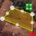
Landreport is a private land mapping tool designed to help landowners, buyers, and real estate professionals view property boundaries, measure land, and identify survey numbers on a digital map. The app assists in estimating property dimensions and understanding land divisions before making real estate decisions.
📌 Key Features:
✔ View Land Boundaries – Check estimated property limits on a digital map (Maharashtra only).
✔ Survey Number Lookup – Identify approximate land survey numbers using map coordinates.
✔ Measure Land Area – Calculate plot size using a digital tool.
✔ Advanced Compass – Get precise property directions for civil work and land marking.
✔ Unit Converter – Convert between Acre, Guntha, Sq. meter, and Sq. foot.
✔ Avoid Fraud – Helps verify land details before making purchase decisions.
✔ Instant Land Reports – Get an estimated mapping of land based on available survey data.
📍 How It Helps:
Assists in land boundary verification.
Helps land buyers make informed decisions by providing reference maps.
Supports surveyors and real estate professionals in land assessment.
💡 Note: This app does not provide maps for legal use. It offers a private reference tool for land mapping based on available data. For legal land records, visit https://bhulekh.mahabhumi.gov.in or contact the local revenue office.
🔗 Website: https://www.landreport.in
🔒 Privacy Policy: https://www.landreport.in/terms.html
Recent changes:
Updated landreport.in
This app is NOT affiliated with the Government of Maharashtra or any official land revenue department. It is an independent service that provides private mapping tools based on publicly available information. Users must verify official land records through the Maharashtra Bhulekh website or relevant government offices.
Landreport is a private land mapping tool designed to help landowners, buyers, and real estate professionals view property boundaries, measure land, and identify survey numbers on a digital map. The app assists in estimating property dimensions and understanding land divisions before making real estate decisions.
📌 Key Features:
✔ View Land Boundaries – Check estimated property limits on a digital map (Maharashtra only).
✔ Survey Number Lookup – Identify approximate land survey numbers using map coordinates.
✔ Measure Land Area – Calculate plot size using a digital tool.
✔ Advanced Compass – Get precise property directions for civil work and land marking.
✔ Unit Converter – Convert between Acre, Guntha, Sq. meter, and Sq. foot.
✔ Avoid Fraud – Helps verify land details before making purchase decisions.
✔ Instant Land Reports – Get an estimated mapping of land based on available survey data.
📍 How It Helps:
Assists in land boundary verification.
Helps land buyers make informed decisions by providing reference maps.
Supports surveyors and real estate professionals in land assessment.
💡 Note: This app does not provide maps for legal use. It offers a private reference tool for land mapping based on available data. For legal land records, visit https://bhulekh.mahabhumi.gov.in or contact the local revenue office.
🔗 Website: https://www.landreport.in
🔒 Privacy Policy: https://www.landreport.in/terms.html
Recent changes:
Updated landreport.in